Pathum Thani ( thaï : ปทุมธานี , prononcé [pā.thūm thāːnīː] ) est l’une des provinces centrales ( changwat ) de la Thaïlande . Les provinces voisines sont (du nord dans le sens des aiguilles d’une montre) : Ayutthaya , Saraburi , Nakhon Nayok , Chachoengsao , Bangkok et Nonthaburi .
| Pathumthani ปทุมธานี | |
|---|---|
| Province | |
  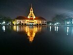  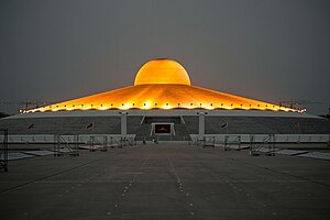 (dans le sens des aiguilles d’une montre à partir du haut à gauche) Mémorial national de Thaïlande , exposition sur une cérémonie royale de labour au musée de l’agriculture du jubilé d’or , balade en tornade dans le monde des rêves , Wat Phra Dhammakaya , musée national des sciences , étang de l’université Thammasat . (dans le sens des aiguilles d’une montre à partir du haut à gauche) Mémorial national de Thaïlande , exposition sur une cérémonie royale de labour au musée de l’agriculture du jubilé d’or , balade en tornade dans le monde des rêves , Wat Phra Dhammakaya , musée national des sciences , étang de l’université Thammasat . |
|
 Drapeau Drapeau  Joint Joint |
|
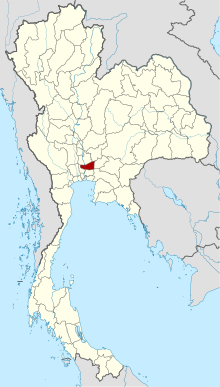 Carte de la Thaïlande mettant en évidence la province de Pathum Thani Carte de la Thaïlande mettant en évidence la province de Pathum Thani |
|
| Pays | Thaïlande |
| Région | Centre de la Thaïlande |
| Capital | Pathumthani |
| Ville la plus grande | Rangsit |
| Gouvernement | |
| • Gouverneur | Narongsak Osotthanakorn (depuis octobre 2021) |
| Région [1] | |
| • Total | 1526 km 2 (589 milles carrés) |
| • Rang | Classé 70ème |
| Population (2019) [2] | |
| • Total | 1 163 604 |
| • Rang | Classé 18ème |
| • Densité | 763/km 2 (1 980/mi carré) |
| • Rang | Classé 5ème |
| Indice de réussite humaine [3] | |
| • IAS (2017) | 0,6384 “élevé” Classé 10ème |
| Fuseau horaire | UTC+7 ( TIC ) |
| Code Postal | 10xxx |
| Indicatif d’appel | 02 |
| Norme ISO 3166 | TH-13 |
| Site Internet | www .eng .pathumthani .go .th |
La province est au nord de Bangkok et fait partie de la zone métropolitaine de Bangkok. Dans de nombreux endroits, la frontière entre les deux provinces n’est pas perceptible car les deux côtés de la frontière sont également urbanisés. La ville de Pathum Thani est le siège administratif, mais Ban Rangsit , siège du District de Thanyaburi , est le plus grand lieu peuplé de la province. [4]
Pathum Thani est une ancienne province, fortement peuplée par le peuple Mon , parsemée de 186 temples et parcs. Le parc d’attractions Dream World est ici. [ citation nécessaire ]
Géographie
La province est située sur les plaines alluviales basses de la rivière Chao Phraya qui traverse la capitale. De nombreux canaux ( khlongs ) traversent la province et alimentent les rizières. Il n’y a pas de zone forestière dans la province. [5]
Histoire
La province de Pathum Thani est habitée depuis au moins 300 ans depuis le règne du roi Narai d’ Ayutthaya . En 1659, Mang Nanthamit fit venir le peuple Mon de la ville de Mottama . Évacuant de la guerre birmane, le roi Narai a donné au peuple Mon une colonie à Ban Sam Khok. Plusieurs années plus tard, sous le règne du Roi Rama II , il y eut une grande migration du peuple Mon de la ville de Mottama vers la Thaïlande appelée “Mon Yai”. Il a également fait vivre à certains Mons à Ban Sam Khok. D’une petite communauté Ban Sam Khok est devenue une ville Sam Khok plus tard.
Plus tard, le 23 août 1815, le Roi Rama II a changé le nom de Sam Khok en la ville de “Pratum Thani”. En 1918, le Roi Rama VI ordonna d’utiliser le mot “province” au lieu de “ville” et changea l’orthographe du nom de “Pratum Thani” en “Pathum Thani”.
En 1932, sous le règne du Roi Rama VII , il ordonna à la province effondrée de Thanyaburi de trouver Pathum Thani. La province de Pathum Thani a divisé la règle en 7 districts comme dans le présent.
Symboles
Le sceau provincial montre une fleur de lotus rose avec deux tiges de riz penchées dessus, représentant la fertilité de la province. L’ arbre provincial est le corail indien ( Erythrina variegata ). La fleur provinciale est le lotus ( Nymphaea lotus ). [ citation nécessaire ]
Éducation et technologie
Pathum Thani a une très forte concentration d’ établissements d’enseignement supérieur, en particulier dans le domaine des sciences et de la technologie . Ceci, combiné à un grand nombre de parcs industriels et d’installations de recherche (y compris ceux du parc scientifique de Thaïlande ), fait de la région le centre éducatif et technologique de la région. [ citation nécessaire ]
Instituts universitaires National Science Museum , Asian Institute of Technology , Bangkok University , Eastern Asia University , North Bangkok University (Rangsit), Pathumthani University , Rajamangala University of Technology , Rangsit University , Shinawatra University , Sirindhorn International Institute of Technology , Thammasat University ( Rangsit Center , et Valaya Alongkorn – Université Rajahbaht ). Organismes de recherche Parc scientifique thaïlandais , Agence nationale de développement des sciences et de la technologie (NSTDA), Centre national de génie génétique et de biotechnologie (BIOTEC), Centre national de technologie des métaux et des matériaux (MTEC), Centre national de nanotechnologie (NANOTEC), Centre national de technologie électronique et informatique (NECTEC ), Thai Microelectronics Center (TMEC), Thailand Institute of Scientific and Technological Research (TISTR), TOT Innovation Institute (TOT) Parcs industriels Software Park Thailand (à Nonthaburi , au sud-ouest de Pathum Thani), Nava Nakorn Industrial Promotion Zone (1376 acres / 5,6 km 2 ), Bangkadi Industrial Park (470 acres / 1,9 km 2 ), Techno Thani (une “Technology City” administrée par la ministère de la Science et de la Technologie), et un certain nombre de parcs industriels dans les provinces voisines d’ Ayutthaya et de Nonthaburi .
divisions administratives
Gouvernement provincial
 Carte de la province de Pathum Thani avec les districts
  Municipalités urbaines ( thesaban nakhon ) Municipalités urbaines ( thesaban mueang ) Municipalités de sous-district ( thesaban tambon )
La province est divisée en sept districts ( amphoes ). Les districts sont subdivisés en 60 communes ( tambons ) et 529 villages ( mubans ).
|
|
Gouvernement local
Au 29 septembre 2020, il y avait: une organisation administrative provinciale de Pathum Thani – PAO ( ongkan borihan suan changwat ) et vingt-neuf zones municipales ( thesaban ) dans la province. Rangsit a le statut de ville ( thesaban nakhon ). Dix autres ont le statut de ville ( thesaban mueang ) et dix-huit municipalités de sous-district ( thesaban tambon ). [2]
| Municipalité de la ville | 1 | Rangsit [6] | 85 260 | ||
| Municipalité. | Personnes | ||||
| 1 | Tha Khlong [7] | 78 108 | 6 | Bueng Yi Tho [8] | 32 708 |
| 2 | Lam Sam Kaéo [9] | 66 003 | 7 | Sanan Rak [10] | 31 350 |
| 3 | Lat Sawaï [11] | 65 906 | 8 | Bang Khu Vat | 28 349 |
| 4 | Khlong Luang [12] | 62 615 | 9 | Pathumthani [13] | 23 633 |
| 5 | Khou Khot [14] | 44 274 | dix | Bang Kadi [15] | 13 987 |
| Sous-district mun. | Personnes | ||||
| 1 | Thanyaburi [16] | 62 990 | dix | Bang Toi | 10 828 |
| 2 | Bang Phun [17] | 25 509 | 11 | Rahaeng | 10 445 |
| 3 | Lak Hok [18] | 21 883 | 12 | Khlong Phra Udom | 7 995 |
| 4 | Lam Luk Ka [16] | 18 377 | 13 | Sam Khok [19] | 6 963 |
| 5 | Bang Duea [20] | 14 756 | 14 | Bang Luang [16] | 6 314 |
| 6 | Bang Khayaeng [21] | 14 557 | 15 | Chiang Rak Yai | 6 260 |
| 7 | Ban Maï [22] | 14 447 | 16 | Khu Khwang [23] | 6 000 |
| 8 | Interdire Klang [24] | 12 326 | 17 | Lam Saï [16] | 2 657 |
| 9 | Nong Sam Wang | 11 016 | 18 | Nong Suéa [16] | 2 901 |
Les zones non municipales sont administrées par 35
organisations administratives de sous-district – SAO ( ongkan borihan suan tambon ). [25]
| Municipalités | Communautés |
| Rangsit [26] | 81 |
| Lam Sam Kaéo [27] | 70 |
| Khlong Luang [28] | 54 |
| Khou Khot [29] | 31 |
| Bueng Yi Tho [30] | 37 |
| Pathumthani [31] | 28 |
| Bang Kadi [32] | 18 |
Indice de réussite humaine 2017
| Santé | Éducation | Emploi | Revenu |
| |
|
|
|
| 4 | 11 | 38 | 13 |
| Logement | Famille | Le transport | Participation |
 |
 |
 |
|
| 68 | 8 | 3 | 76 |
| La province de Pathum Thani, avec une valeur HAI 2017 de 0,6384 est “élevée”, occupe la 10e place du classement. |
Depuis 2003, le Programme des Nations Unies pour le développement (PNUD) en Thaïlande suit les progrès du développement humain au niveau infranational à l’aide de l’ Indice de réussite humaine (IAH), un indice composite couvrant les huit domaines clés du développement humain. Le Conseil national de développement économique et social (NESDB) a repris cette tâche depuis 2017. [3]
| Rang | Classification |
| 1 – 15 | “haute” |
| 16 – 30 | “un peu élevé” |
| 31 – 45 | “moyen” |
| 45 – 60 | “un peu faible” |
| 61 – 77 | “bas” |
| Carte avec les provinces et les classements HAI 2017 | |
 |
Références
- ^ Faire progresser le développement humain grâce à la communauté de l’ANASE, Rapport sur le développement humain en Thaïlande 2014, tableau 0 : Données de base (PDF) (Rapport). Programme des Nations Unies pour le développement (PNUD) Thaïlande. p. 134–135. ISBN 978-974-680-368-7. Récupéré le 17 janvier 2016 , les données ont été fournies par le Département de l’aménagement du territoire, ministère de l’Agriculture et des Coopératives, à Wayback Machine.{{cite report}}: CS1 maint: postscript (link)[ lien mort ]
- ^ un b “สถิติทางการทะเบียน” [Statistiques d’enregistrement]. bora.dopa.go.th . Département de l’administration provinciale (DOPA). décembre 2019 . Récupéré le 22 septembre 2020 . Télécharger จํานวนประชากร ปี พ.ศ.2562 – Télécharger année de population 2019
- ^ a b Indice de réussite humaine 2017 par le Conseil national de développement économique et social (NESDB), pages 1-40, cartes 1-9, récupéré le 14 septembre 2019, ISBN 978-974-9769-33-1
- ^ “Population Statistics 2008”. Department of Provincial Administration. Archived from the original on 2010-03-25. Retrieved 2010-06-28. Pathum Thani town population 18,843; Rangsit town population 76,843
- ^ “ตารางที่ 2 พี้นที่ป่าไม้ แยกรายจังหวัด พ.ศ.2562” [Table 2 Forest area Separate province year 2019]. Royal Forest Department (in Thai). 2019. Retrieved 6 April 2021, information, Forest statistics Year 2019{{cite web}}: CS1 maint: postscript (link)
- ^ “ประกาศกระทรวงมหาดไทย เรื่อง เปลี่ยนแปลงฐานะเทศบาลเมืองรังสิต อําเภอธัญบุรี จังหวัดปทุมธานี เป็นเ ทศบาลนครรังสิต พ.ศ.๒๕๕๔” [Announcement from the Ministry of Interior Re: Change Rangsit town municipality, Thanyaburi district, Pathum Thani province to Rangsit city municipality B.E.2554 (2011).] (PDF). Royal Thai Government Gazette. 128 (Special 61 Ngor): 42. 1 June 2011. Retrieved 31 October 2019.
- ^ “พระราชฤษฎีกา จัดตั้งเทศบาลเมืองท่าโขลง พ.ศ.๒๕๔๔” [Royal Decree: Establish of Tha Khlong town municipality B.E.2544 (2001)] (PDF). Royal Thai Government Gazette. 118 (93 Kor): 25–27. 9 October 2001. Retrieved 12 December 2019.
- ^ “ประกาศกระทรวงมหาดไทย เรื่อง เปลี่ยนแปลงฐานะเทศบาลตําบลบึงยี่โถ อําเภดธัญบุรี จังหวัดปทุมธาบี เป็นเทศบาลเมืองบึงยี่โถ พ.ศ.๒๕๕๕” [Notification of the Ministry of Interior: Change status of Bueng Yi Tho subdistrict municipality, Thanyaburi district, Pathum Thani province to Buen Yi Tho town municipality B.E.2555 (2012)] (PDF). Royal Thai Government Gazette. 129 (Special 13 Ngor): 44. 11 January 2012. Retrieved 12 December 2019.
- ^ “ประวัติความเป็นมา” [History]. lamsamkaeo.go.th (in Thai). 2020. Retrieved 30 October 2020. Lam Sam Kaeo SAO upgraded to Lam Sam Kaeo town municipality on 1 August 2007.
- ^ “ประกาศกระทรวงมหาดไทย เรื่อง เปลี่ยนแปลงฐานะเทศบาลตําบลสนั่นรักษ์ อําเภดธัญบุรี จังหวัดปทุมธาบี เป็นเทศบาลเมืองสนั่นรักษ์ พ.ศ.๒๕๔๗” [Notification of the Ministry of Interior: Change status of Sanan Rak subdistrict municipality, Thanyaburi district, Pathum Thani province to Sanan Rak town municipality B.E.2547 (2004)] (PDF). Royal Thai Government Gazette. 121 (Special 78 Ngor): 1–2. 19 July 2004. Retrieved 12 December 2019.
- ^ “Number of local government organizations: Summary elevating local authorities”. dla.go.th. Department of Local Administration (DLA). 23 September 2011. Retrieved 25 September 2020. No.3.1 Established Lat Sawai Subdistrict Administrative Organization (SAO), Lam Luk Ka district, Pathum Thani province is Lat Sawai town municipality, effectively 1 October 2011.
- ^ “ประกาศกระทรวงมหาดไทย เรื่อง เปลี่ยนแปลงฐานะเทศบาลตําบลคลองหลวง อําเภดคลองหลวง จังหวัดปทุมธาบี เป็นเทศบาลเมืองคลองหลวง พ.ศ.๒๕๔๘” [Notification of the Ministry of Interior: Change status of Khlong Luang subdistrict municipality, Khlong Luang district, Pathum Thani province to Khlong Luang town municipality B.E.2548 (2005).] (PDF). Royal Thai Government Gazette. 122 (Special 84 Ngor): 6. 14 September 2005. Retrieved 12 December 2019.
- ^ “พระราชกฤษฎีกา จัดตั้งเทศบาลเมืองปทุมธานี จังหวัดปทุมธานี พุทธศักราช ๒๔๗๙” [Royal Decree: Establishing of Pathum Thani town municipality, Pathum Thani province, Buddhist Era 2479 (1936).] (PDF). Royal Thai Government Gazette. 53: 828–831. 29 November 1936. Retrieved 10 October 2020.
- ^ “พระราชกฤษฎีกาจัดตั้งเทศบลเมืองคูคต พ.ศ.๒๕๓๙” [Royal Decree: Establish of Khu Khot town municipality B.E.2539 (1996).] (PDF). Royal Thai Government Gazette. 113 (5 Kor): 4–7. 6 March 1996. Retrieved 31 October 2019.
- ^ “ประกาศกระทรวงมหาดไทย เรื่อง เปลี่ยนแปลงฐานะเทศบาลตําบลบางกะดี อําเภดเมืองปทุมธานี จังหวัดปทุมธาบี เป็นเทศบาลเมืองบางกะดี” [Notification of the Ministry of Interior: Change status of Bang Kadi subdistrict municipality, Mueang Pathum Thani district, Pathum Thani province to Bang Kadi town municipality.] (PDF). Royal Thai Government Gazette. 137 (Special 204 Ngor): 10+11. 8 September 2020. Retrieved 25 September 2020.
- ^ a b c d e “พระราชกฤษฎีกา เปลี่ยนแปลงฐานะของสุขาภิบาลเป็นเทศบาล พ.ศ.๒๕๔๒” [Royal Decree: Change Sanitation district to Municipality Act B.E.2542.] (PDF). Royal Thai Government Gazette. 116 (9 Kor): 1–4. 24 February 1999. Retrieved 10 October 2020, effective 25 May 1999.{{cite journal}}: CS1 maint: postscript (link)
- ^ “Number of local government organizations: Summary elevating local authorities”. dla.go.th. Department of Local Administration (DLA). 2 September 2011. Retrieved 9 September 2020. No.4.14 Established Bang Phun Subdistrict Administrative Organization (SAO), Mueang Pathum Thani district, Pathum Thani province is Bang Phun subdistrict municipality, effectively 30 September 2011.
- ^ “ประวัติหน่วยงาน” [History of the Agency]. lakhok.go.th (in Thai). 2020. Retrieved 30 October 2020. Lak Hok SAO upgraded to Lak Hok subdistrict municipality on 24 August 2007.
- ^ “Number of local government organizations: Summary elevating local authorities”. dla.go.th. Department of Local Administration (DLA). 4 August 2011. Retrieved 25 September 2020. No.4.2 Established Sam Khok Subdistrict Administrative Organization (SAO), Sam Khok district, Pathum Thani province is Sam Khok subdistrict municipality, effectively 1 October 2011.
- ^ “Number of local government organizations: Summary elevating local authorities”. dla.go.th. Department of Local Administration (DLA). 2 September 2011. Retrieved 17 September 2020. No.4.12 Established Bang Duea Subdistrict Administrative Organization (SAO), Mueang Pathum Thani district, Pathum Thani province is Bang Duea subdistrict municipality, effectively 30 September 2011.
- ^ “Number of local government organizations: Summary elevating local authorities”. dla.go.th. Department of Local Administration (DLA). 30 September 2011. Retrieved 30 October 2020. No.4.49 Established Bang Khayaeng Subdistrict Administrative Organization (SAO), Mueang district, Pathum Thani province is Bang Khayaeng subdistrict municipality, effectively 30 September 2011.
- ^ “Number of local government organizations: Summary elevating local authorities”. dla.go.th. Department of Local Administration (DLA). 4 August 2011. Retrieved 25 September 2020. No.4.1 Established Ban Mai Subdistrict Administrative Organization (SAO), Mueang Pathum Thani district, Pathum Thani province is Ban Mai subdistrict municipality, effectively 1 October 2011.
- ^ “Number of local government organizations: Summary elevating local authorities”. dla.go.th. Department of Local Administration (DLA). 2 September 2011. Retrieved 17 September 2020. No.4.11 Established Khu Kwang Subdistrict Administrative Organization (SAO), Lat Lum Kaeo district, Pathum Thani province is Khu Kwang subdistrict municipality, effectively 30 September 2011.
- ^ “Number of local government organizations: Summary elevating local authorities”. dla.go.th. Department of Local Administration (DLA). 2 September 2011. Retrieved 9 September 2020. No.4.13 Established Ban Klang Subdistrict Administrative Organization (SAO), Mueang Pathum Thani district, Pathum Thani province is Ban Klang subdistrict municipality, effectively 30 September 2011.
- ^ Department of Provincial Administration (DOPA), List of 5,324 SAO’s information as of date 20 December 2019, 35 SAO’s (no.2116-2151) were established in 1994 (1), in 1995 (19), in 1996 (10) and in 1997 (5).
- ^ “ด้านชุมชน” [Community side]. rangsit.org (in Thai). 2020. Retrieved 30 October 2020. 81 communities.
- ^ “กลุ่มอค์กร” [Organization groups]. lamsamkaeo.go.th (in Thai). 2020. Retrieved 30 October 2020. 70 communities.
- ^ “ชุมชน” [Communities]. khlongluang.go.th (in Thai). 2020. Retrieved 30 October 2020. 54 communities.
- ^ “ข้อมูลชุมชน” [Community information]. khukhot.go.th (in Thai). 2020. Retrieved 30 October 2020. 31 communities.
- ^ “1. สภาพทั่วไป (5.3)” [1. General (5.3)]. buengyitho.go.th (in Thai). 2020. Retrieved 30 October 2020. 37 communities.
- ^ “ข้อมูลเทศบาล” [Municipal information]. muangpathum.org (in Thai). 2020. Retrieved 30 October 2020. 28 communities.
- ^ “ชุมชน” [Communautés]. bangkadi.go.th (en thaï). 2020 . Récupéré le 30 octobre 2020 . 18 communes.
Liens externes
-
 Guide de voyage Pathum Thani de Wikivoyage
 - Pathumthani ; Autorité du tourisme de Thaïlande
- Universités et collèges à Pathum Thani à Curlie
Coordinates: 14°1′15′′N 100°31′29′′E / 14.02083°N 100.52472°E / 14.02083; 100.52472